


Description
WinATLAS - 3D Map Data Collection & Editing
WinATLAS is our standard tool for digitizing and editing map data. It forms the basis for our softcopy stereoplotter WinATLAS/DSP, and it supports online input from most analog and analytical stereoplotters, as well as a variety of digitizing tablets. The program provides multiple ways to access the different collection modes and editors. This makes it straightforward and intuitive for new users, and fast for experienced users. It was designed as a double precision 3D tool for the making of maps. It works in UTM, State Plane or assumed coordinates, and with either English or Metric units. It is constantly evolving to take advantage of innovations in computer and imaging technology, as well as adding features needed by our clients to meet the needs of their clients. And yet with all the evolution of technology you can stilll load and update files that were archived thirty years ago as if they were just saved yesterday.
The ease of using WinATLAS begins with loading and storing files. If you wish to load multiple files into a single workspace, then you merely select multiple files from a list of those available in the Project directory and they are loaded. If you have loaded files that you no longer need, you can unload them. If you are working in a new area and want to tie to existing data, the program will automatically scan all the files in the target directory and load only those that adjoin the current workspace. When you are edge matching, adjoining files can be loaded for Reference Only. Since the import translators are built into WinATLAS, files from multiple platforms can be loaded into the same workspace. In short, if you can use the operating system, you can load, merge, reference, tie, import, unload and store data files in WinATLAS.
 Continuous, mixed-mode line capture allows you to digitize arcs, fillets, straight line segments and splined curves all as part of the same line. When collecting a road edge, for example, you can collect the fillet at the corner, the curve in the middle, the straight segments in between, and the circular cul-de-sac at the end, all without changing modes, breaking the line, or pressing more than one button to collect the next data point. In the example to the right, each colored circle represents a single push of a button, going counter-clockwise around the cul-de-sac. The yellow circles represent points taken in straight line mode with the F1 button. Points at red circles were digitized with the F5 button set to tangential arc with computed radius. And the blue circles represent points on arc digitized with the F3 button.
While editing or collecting data you can Find or Snap to existing points, vertices, lines, line intersections or line midpoints in either 2D or 3D mode with the press of a single button. For example, you can snap one end of a driveway to the roofline of a house with a 2D Line Find, causing the XY coordinates of this endpoint of the driveway to intersect the roofline, while the Z coordinate remains on the ground as digitized. And then snap the other end of the driveway to the street with a 3D Line Find, causing the XYZ coordinates of this endpoint to lie exactly on the street line. WinATLAS can also insert an additional data point in the street line at the snap point.
When editing map data for final submission you can eliminate time spent looking for problems in data that is clean and ready to go. Used in conjunction with WinBatch you can automatically find and mark a wide variety of problems that require interactive editing. In WinATLAS you can zoom in close and drive from marker to marker with the push of a button, fixing the problems as you go. You will always know how many problems remain to be fixed and, when you are finished, the data will be clean. If a large map tile contains only two markers, you can fix those two problems and be done. There is no need to painstakingly search for problems that do not exist.
WinBatch - Automated 3D Map Data Editing
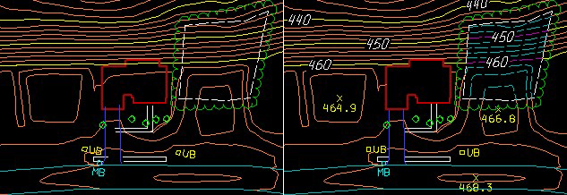
WinBatch is a set of tools that allow you to automatically check, correct and enhance your mapping data. Basically, you create and execute scripts that perform a set of functions on one or more of your map data files. These scripts are created using an interactive menu, and then run in the background without any further user interaction.
For example, a WinBatch script was used in the graphic above to:
- Load the existing data file
- Hang & Clip driveways to roads and buildings
- Hang & Clip sidewalks to buildings and driveways
- Place Spot Heights on tops
- Change contour lines in obscured areas from solid to dashed
- Change symbol rotations from model to final map tile rotations
- Erase inside buildings
- Generate contour annotation on index contours
- Erase contour lines under text
- Store the edited data file under a new name
You can spend less time on manual data capture and editing, because WinBatch script files make it easy to check and standardize your vector data before exporting it to CAD or GIS systems.
Frequently used WinBatch functions include:
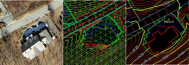
WinATLAS/TIN - Contour Generation
Our TIN option is fully integrated with our WinATLAS and WinATLAS/DSP products to give you interactive contour generation inside our standard map data collection & editing software for analog, analytical and softcopy stereoplotters.
Features:
- Interactive build and edit
- Interactive and static parameters
- Triangle models from multiple sources
- Threaded contour generation
- Splined contour generation with applied filtering
Computed Volumetrics:
- Differences between TINs
- Differences between active TIN and static elevation
- Volume reports
TIN Utilities:
- Compress TIN
- Contours to TIN
- 2D CAD to 3D
- Extract gridded DTMs
- TIN exports to: DXF, DGN, Arc Shapefile, and DTM formats
WinTINViewer visualization tool:
- 3D solids modeling
- Generate fly throughs
- Generate MPEG/AVI movies
WinATLAS/DSP - SoftCopy Stereoplotter
WinATLAS/DSP, or Digital StereoPlotter, is a full-featured, Windows-based, SoftCopy Photogrammetric Workstation built around our WinATLAS 3D map data collection and editing package. The software uses multi-threaded code to take advantage of today’s multi-processor CPUs. It runs on standard, commercially available PC workstations under Windows XP, Windows 7 and Windows 8, but requires a stereo-ready multi-GPU graphics card like one of the NVIDIA® Quadro series.
Image viewing options include:
- Stereomodels • Double models • Quad models
- Orthos • Rasters • Photos
- LIDAR (mono and stereo) • RADAR (mono and stereo)
- Top View • Perspective View • Profile View
- Microscope • Telescope • Multi Ray
- Reference images, including cloud-based Google® Maps Satellite, Maps Oblique, Maps Road, Maps Terrain, Streetview and Earth 3D
Our real-time image processing includes:
- Moving cursor, smooth auto panning or • Fixed cursor, smooth moving image
- Continuous zoom and rotation • Brightness and contrast control
- Auto panning from model to model • Epipolar correction on the fly
- Hot-key to automatically put the dot on the ground using image correlation
(really useful for training new stereo operators)
Image files can come from:
- Scanned diapositives from film mapping cameras like the RC20, RMKTOP, etc.
- Large-format digital frame cameras like the DMC and UltraCam
- Medium-format digital frame cameras like DSS, NexVue and Rollei
- Digital line scanner Level 0 data from ADS40, ADS80, 3DAS1
- Satellite imagery such as IKONOS, Quickbird, SPOT5, NITF, etc.
- Uncalibrated non-metric cameras
WinATLAS/DSP supports all available stereoviewing devices, including NuVision® and Planar® systems, as well as the lower-cost NVIDIA 3D Vision with a single stereo-capable LCD monitor. 3D motion-control hardware options include:
- Traditional handwheels/footdisk/footpedals
- 3D photogrammetric cursors like the Stealth S3-Z and SoftMouse 3D-USB
- Even your workstation’s existing keyboard and mouse
gpSpeedPack - The power of a GPU with multiple CPUs
A KLT gpSpeedPack license enables our computation-intensive programs to take advantage of the Graphics Processing Unit (“GPU”) found on most of today’s graphics cards. This GPU is composed of multiple CPUs that can perform independent calculations in parallel, at the same time.
For example, when computing orthophotos, for each (x,y,z) pixel in the orthophoto we need to calculate the corresponding source (x,y,z) pixel(s) in the original photo(s). The 3D transformation from one reference system to another takes into account the omega/phi/kappa rotations, the scale difference and the (x,y,z) reference shifts:
Ynew = Myx*Xold + Myy*Yold + Myz*Zold + Ty
Znew = Mzx*Xold + Mzy*Yold + Mzz*Zold + Tz
An ordinary computer would be programmed to perform these 9 multiplications and 9 additions in serial, one after the other. With a GPU, the 9 multiplications happen on 9 different CPUs in parallel, at the same time! In fact, because most of the computation is off-loaded to the GPU, the main system CPUs can do a better job with image handling and filing.
In order to take advantage of parallel processing, each of our computation-intensive programs, like AIRTRIG and TERRAIN, had to be completely rewritten from scratch. These are not simple updates to a program to accommodate a new camera, or a new image format. They are new replacement products: gpAIRTRIG64 and gpTERRAIN64, etc. And, yet, we are reluctant to ask our clients to purchase AIRTRIG or ORTHO software again. Instead, we offer the new gpSpeedPack license, which works alongside your existing ORTHO, or AIRTRIG, or TERRAIN licenses, and entitles you to use the new gp64 products.
If you’re using our ORTHO, AIRTRIG, TERRAIN products on an x64 computer with an appropriate graphics card, and you want things to run 10 times faster, then you should try out our gpSpeedPack license.
ProjectOrtho
ProjectOrtho provides an efficient, highly automated workflow for producing orthos, whether it be a single orthophoto or a county-wide orthomosaic.
KATS - KLT Aerial Triangulation System
Windows based measurement and adjustment:
- Single integrated environment for measurement, adjustment and analysis
- Handles large blocks, e.g. 2000 photos
- Imagery and graphics superimposition
- Multi-model manual stereo measurement, e.g. quad model
- Drive-to functions from scheme measurement and ground control
Automation:
- Automatic Inner Orientation, no initial manual measurement required
- Automatic Relative Orientation
- Automatic Strip
- Across Strip Block
- Automatic AT that doesn’t require ab-GPS and IMU to launch
- Automatic digital camera setup
AT Processes:
- As an option to the user, ab-GPS and IMU can assist auto-AT
- Handles DTM surface to assist auto-AT
- Stereo tools to check auto-AT
- Multi-ray handling: unlimited in math model, 32 ray points in mono measurement tool
- Choice of any 4 models viewed in stereo
- Handles any strip/block/kappa arrangement
- Uses ab-GPS and IMU, including shift/drift parameters
- Processes IMU boresighting calibration flight or extra parameters
- Works for camera calibration flights
- Optional geodetic constraints such as lines/distances/angles
- Handles close range blocks
Error Detection:
- Various blunder detection schemes
- Full error propagation
- Various statistics on adjustment
Automatic AT of:
- Scanned imagery from film mapping cameras like RC30, RC20, RMKTOP, Jena, etc.
- Large format digital frame cameras such as ZI-DMC and UltraCam
- Medium format digital cameras like DSS, NexVue and Rollei
- Satellite physical models such as SPOT5, RPC, IKONOS, QuickBird
- Non-metric uncalibrated cameras
- Digital line scanner Level 0 such as ADS40, 3DAS1 and SI290
TERRAIN - Working with Huge Point Datasets
The KLT TERRAIN program can process DTMs with hundreds of millions of data points. It is used for:
- Displaying correlated or LIDAR digital surface models (DSMs)
- Interpolating gridded DTMs and contours from huge point datasets
- Cutting and sorting DTM files into new sheets
- Extracting DSMs from aerial imagery by correlation
- Classifying DSMs
- Displaying point datasets in 3D perspective or profile views
- Generating LIDAR stereograms for stereo handling of point datasets
DTM Point Data
With TERRAIN you can open one or multiple files of random mass points, raw LIDAR data, and/or gridded DTMs. The files can be irregular spaced formats like:
- LAS (a public file format for the interchange of LIDAR data)
- KLT ATLAS (either native or by importing DXF, DGN, etc. files)
- ASCII (e.g. XYZ, RXYZI, XYZRI, CXYZI, TXYZXYZII, YXZ, etc.)
Or the data files can be regular spaced grid formats like:
- USGS DEM
- USGS SDTS DEM (*CATD.DDF)
- NIMA DTED (*.DT?)
- Japan GSI DEM (*.MEM)
- ArcInfo ASCII grid interchange (from ASCIIGRID) (*.ASC/*.PRJ)
- ArcInfo binary grid (HDR.ADF)
- ESRI .HDR labeled BIL (*.HDR/*.BIL) (can be 8/16/32-bit integer and 32-bit floating point)
- TIFF (can be 16-bit integer or 32-bit floating point, strip or tiled)


Reviews
There are no reviews yet.